A very close look at Korea’s Demilitarized Zone

Scores of South Koreans wait their turn to get a glimpse of the Demilitarized Zone and North Korea. The two nations have been in a state of war since 1951. Hope remains that one day the two nations will be reunited.
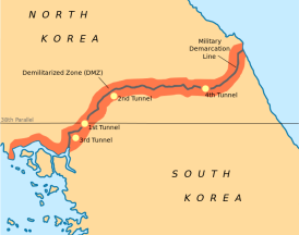
A map showing the Deimilitarized Zone separating North Korea from South Korea. (Click on photos to enlarge.)
Brief Korean War history
The Korean War (1950 to 1953) was a war between North and South Korea, in which a United Nations force led by the United States was fighting alongside the South, and China, assisted by the Soviet Union, was fighting alongside the North. The war arose from the division of Korea at the end of World War II and from the global tensions of the Cold War that developed immediately afterwards.
The Korean Armistice Agreement is the treaty which ended hostilities between North Korea and South Korea. It was signed by U.S. Army Lieutenant General William Harrison, Jr. representing the United Nations Command (UNC), North Korean General Nam Il representing the North Korean People’s Army, and the Chinese People’s Volunteer Army. The armistice was signed on July 27, 1953, and was designed to “insure a complete cessation of hostilities and of all acts of armed force in Korea until a final peaceful settlement is achieved.” So far, no “final peaceful settlement” has been achieved.
During the three years of war, South Korea had suffered 217,000 military casualties and more than 1 million citizens had died. North Korea had suffered 406,000 military casualties and an estimated 600,000 of its citizens had been killed. According to the US Department of Defense, more than 30,000 US troops died and another 103,284 were wounded. Thousands of troops are still classified as POWs or MIAs.
If we could push a button and end war on planet Earth we would no doubt do it. Such statistics as mentioned above are grim reminders that war is never a good response to disagreements and conflicts. We must find far better ways to negotiate a just and lasting peace.
Visiting the Demilitarized Zone
At the end of the World Peace Summit in Seoul, my colleagues, Dr. Sadig Malki from Saudi Arabia, and Bernard van Maele from Belgium, and I grabbed a taxi from in front of the Seoul Renaissance Hotel and took off for the Korean Dimilitarized Zone (DMZ) some 50 kilometers to the north. It is 250 kilometres (160 miles) long, approximately 4 km (2.5 mi) wide.
The name “Demilitarized Zone” is actually an oxymoron. It is in reality one of the most heavily militarized strips of land in the world. Occasional skirmishes and shelling still take place.
The DMZ cuts the Korean Peninsula roughly in half, crossing the 38th parallel on an angle, with the west end of the DMZ lying south of the parallel and the east end lying north of it. It was created as part of the Korean Armistice Agreement between North Korea, the People’s Republic of China, and the United Nations Command forces in 1953.
Our taxi attempted to drive directly to the Dora Observatory, but UN forces waved us away. We were told we had to go to a nearby location and transfer to a tour bus. The Dora Observatory is a large outpost overlooking the DMZ and North Korea. From the observatory, visitors can get an excellent view of the DMZ and North Korean towns and the mountains that lay beyond. This observation post was first opened to the public in January 1987.
Hundreds of South Koreans crowded around telescopes as they sought to get a glimpse of life in North Korea. Looking through a telescope, I didn’t see any sign of movement or life. I didn’t see any people walking around or any traffic on the streets.
It reminded me of my first visit to Berlin, Germany, in 1967. I was just 18 years old. I had walked along the Berlin Wall. On one side of the wall I saw the bustling businesses and tall skyscrapers of West Berlin. On the East Berlin communist side there was little evidence of economic growth or activity. It was as though I was peering into a time warp. Many buildings still lay in ruins from World War II.
DMZ invasion tunnels
At our first stop, Bernard, Sadig and I walked through a DMZ museum where we learned about the possibility of visiting a network of tunnels that had been dug by the North Korean military. We were told they are “invasion tunnels” that were meant to send infiltrating forces into South Korea.
According to one declassified intelligence report I read, it is believed that North Korea began digging the tunnels after then president Kim Il-sung issued the September 25, 1971, Combat Readiness Order. In that directive, Kim stressed the need to dig tunnels under the Demilitarized Zone, saying that “one tunnel would be more effective than 10 atomic bombs” and would thus be the best means of overwhelming the heavily fortified South Korean army.
Tunnel One was discovered in November 1974 in the Western Sector of the DMZ near Gorang-po. At an estimated length of 3.5 kilometers, it extends one kilometer south of the Military Demarcation Line that divides the DMZ. The walls and ceiling of the tunnel, 1.2 meters high and nearly a meter wide, are reinforced with concrete slabs. It has the capacity to move an entire regiment through it. The tunnel was lit with lamps connected to 220-volt power lines. Equipped with a narrow-gauge railway, rail cars and drainage devices were also found inside. This tunnel is located only 65 kilometers north of South Korea’s capital Seoul.
Twice as wide as Tunnel One, Tunnel Two was discovered in March 1975 in the Central Sector of the DMZ, about 13 kilometers north of the town of Cheorwon. Measuring two meters high and just over 2 meters wide, the arch-shaped tunnel is large enough to move heavy weapons like tanks, field artillery, and armored personnel carriers. More than 30,000 troops per hour could be moved through the tunnel into the South. It was bored through 3.5 kilometers of bedrock at a depth of 50-160 meters below ground. A spacious troop assembly area was carved out inside the tunnel. There were three exits from the assembly area leading to the surface.
Tunnel Four, which is located along one of the most strategic routes in the Eastern Sector, was discovered in March 1990 only 26 kilometers northeast of Yanggu. This tunnel is buried at an average depth of 145 meters below ground and measures two meters high and two meters wide.
Almost identical with Tunnel Two and Tunnel Three in size and structure, Tunnel Four goes just over 1 kilometer south of the Military Demarcation Line and is designed to infiltrate massive forces into the Sohwa-Wontong corridor, the major access route to the Yeongdong Expressway.
Down, down we go
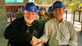
Donning hard hats to prevent head injuries from hanging rocks, we boarded a small passenger tram, travelling some two kilometers and far beneath the surface into Tunnel 2. The tram had been built by South Korea to provide its citizens with a vivid account of the invasion tunnels that threatened the South.
The South Korean Defense Ministry still officially looks for tunnels as it believes there may be as many as 20 of these military corridors, but we are told the budget is small and tunnel hunters believe it is merely a token effort. As we move deeper beneath the DMZ a speaker system explains that North Korea has said the tunnels were not for invasion, but part of its “mining industry.”
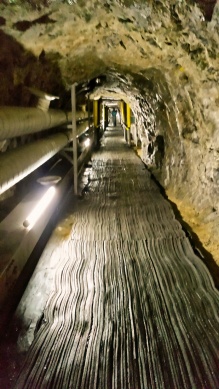
North Korea officially declared Tunnel Two to be a coal mine. Comically black “coal” was painted on the walls by retreating North Korean soldiers to help prove this. There is no geological likelihood of coal being in the area, we’re told. “The walls are noticeably granite,” we’re told. “It is highly unlikely that coal would ever be found in such geological conditions.”
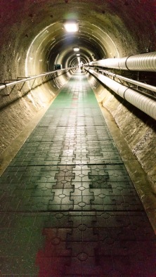
An access channel built by the South Koreans as a conduit to North Korea’s Tunnel Four. This is the two-kilometer upgrade Sam faced when returning to the bus.
My great adventure—Tunnel Four!
We eventually surfaced from that tunnel, and I thought I was following Sadig and Bernard into an access channel leading to the much longer Tunnel Four.
Wondering how they had gotten so far ahead of me, I kept moving down the steep grade. There was no tram to ride in Tunnel Four. I kept on moving down, down the steep incline into the ground, walking about 2 kilometers. All the time I’m thinking, “Good grief! I’ll never make it back up this tunnel!”
Towards the end, I realized Bernard and Sadig were not ahead of me, and I was alone in this man-made cavern. I also realized there was no easy way out–not tram or elevator could be found. There I was some 120 meters beneath the middle of the DMZ! I eventually found myself peering through a hole in a door. There was a sign “Restricted Area!” That door, I was told later, led directly into North Korea!
I began walking back in the opposite direction, and after about 30 minutes I finally found my way back to that steep passage way leading to the exit. As I began moving slowly back up the steep two-kilometer incline, I heard a message blaring over the PA system: “Meester Sam. If you in tunnel back to bus! Go fast please! Bus leaving!”
I began running up that corridor, huffing and puffing and stopping now and then to lean on the rail to catch my breath. What a tremendous workout! I was wondering how many older men like me had died of heart-attacks alone down there!
When I finally made it out I was soaking wet from sweat. I practically crawled into the bus. Bernard and Sadig were relieved to see me while another 30 Korean tourists seemed a bit annoyed with an American who was holding up the bus. I apologized to all, bowing profusely. They in turn smiled kindly as Koreans do. And I thought to myself, “What an incredible adventure!”
DMZ–a wildlife refuge
Despite the posturing and the insults hurled across this narrow strip of land, the DMZ has become a haven for wildlife and plants in the region. “It’s kind of the irony of war,” said Hall Healy, chairman of the board of the International Crane Foundation, which has worked with researchers and locals near the DMZ on red-crowned crane conservation.
Species that have dwindled or disappeared in some parts of Asia have found refuge in the DMZ. Sightings of rare birds, such as red-crowned cranes and white-naped cranes, are not unusual. Black bears, musk deer, and Amur gorals—a goat relative that lives in the mountains—also inhabit this heavily fortified area.
No videoing of the invasion tunnels is permitted, and in places no photos are permitted. I did find the following short video of one of the invasion tunnels on YouTube. It accurately portrays what we saw:
Sources: History Magazine, wikipedia.org, Republic of South Korea Ministry of Tourism, US Department of Defense, historylearningsite.co.uk, korea.net
No comments yet.
-
Archives
- November 2018 (1)
- June 2018 (1)
- December 2016 (1)
- November 2016 (1)
- June 2016 (1)
- May 2016 (1)
- July 2015 (1)
- March 2015 (2)
- February 2015 (1)
- October 2014 (3)
- September 2014 (2)
- August 2014 (1)
-
Categories
-
RSS
Entries RSS
Comments RSS




Leave a comment